draft
Geography / 地理
Overview / 概要
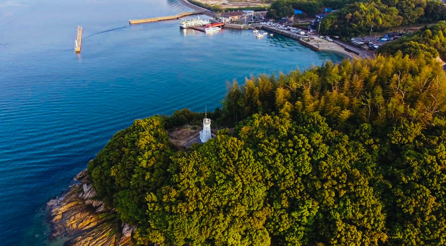
Sagishima (佐木島) is a small island in the Seto Naikai (瀬戸内海, the Seto Inland Sea), the protected ribbon of water between Honshū and Shikoku. The Red Dot School's About page places it more precisely "between Hiroshima and Ehime prefectures." It sits within the administrative area of Mihara City (三原市), Hiroshima Prefecture (広島県), and is reached by ferry from Mihara Port (roughly a 13 to 15 minute crossing from near Shinkansen Mihara Station) or from Onomichi (尾道), depending on schedule and season. The island is hilly and small enough to walk around in a day.
佐木島は、本州と四国にはさまれた穏やかな海域である瀬戸内海にある小さな島である。レッドドットスクールのAboutページは、より正確に「広島県と愛媛県のあいだ」と位置づけている。行政上は広島県三原市に属し、三原港から(新幹線の三原駅近くからおよそ13〜15分の渡航)、あるいは時刻表や季節に応じて尾道からフェリーで渡る。島は丘が多く、一日で歩いて回れるほどの大きさである。
What we know / わかっていること
- Surface area: 8.72 km² (now resolved). The Japanese Wikipedia article on 佐木島, drawing on official figures, gives 面積 8.72 km² and 周囲 (perimeter) 18.2 km, matching the Old Home page. The competing "6.3 sq mi / ~16.3 km²" on the Sagishima Data Project and /our-studios pages is almost certainly a unit error: the live RDS site even prints the self-contradictory "6.3 square miles (8.72 km²)" (6.3 sq mi ≈ 16.3 km²; 8.72 km² ≈ 3.37 sq mi). Treat 8.72 km² as the island's land area; the 16.3 figure was a mislabel. (See open questions.) 面積:8.72 km²(解決済み)。 佐木島に関する日本語版ウィキペディアは、公式の数値に基づいて面積 8.72 km²と周囲 18.2 kmを示しており、Old Homeのページと一致する。佐木島データ・プロジェクトと /our-studios のページにある「6.3 sq mi/約16.3 km²」という食い違う数値は、ほぼ確実に単位の誤りである。現行のRDSサイトは「6.3 square miles (8.72 km²)」という自己矛盾した表記まで載せている(6.3 sq mi ≈ 16.3 km²、8.72 km² ≈ 3.37 sq mi)。島の陸地面積は8.72 km²として扱い、16.3という数値は誤った表記であった。(未解決の問いを参照。)
- Highest point and shape. The island's high point is Taiheizan (太平山), 267.5 m; the coastline runs about 18.2 km around. Small neighboring Kosagishima (小佐木島) shares some of the ferry routes. 最高地点と形。 島の最高地点は太平山(267.5 m)で、海岸線はおよそ18.2 kmにわたる。隣接する小さな小佐木島は、一部のフェリー航路を共有している。
- The hills remember their cultivation. Formerly farmed terrain has been lightly reforested with poplar and bamboo; bamboo's shallow roots make the slopes more landslide-prone than when actively worked. (Per the Thirsty Island sub-project; see Hydrology and the Water Question.) 丘は耕作の記憶をとどめている。 かつて耕されていた土地は、ポプラと竹でゆるやかに再生林化しており、竹の根は浅いため、斜面は活発に耕されていた頃よりも崩れやすくなっている。(渇いた島のサブプロジェクトによる。水の問いを参照。)
- Walk it. The island is small enough that a single day on foot changes how the rest of the wiki reads. 歩いてみること。 島は小さく、一日歩いて回るだけで、このウィキの残りの読み方が変わってくる。
Related / 関連
Open questions / 未解決の問い
- The area question is now effectively resolved (8.72 km² per official figures via Wikipedia; 16.3 km² was a unit error). A Mihara cadastral source would confirm it definitively. See open questions. 面積の問いは、事実上すでに解決している(ウィキペディア経由の公式数値で8.72 km²、16.3 km²は単位の誤り)。三原市の地籍資料があれば、決定的に確認できるだろう。未解決の問いを参照。
Named heights, islets, and viewscapes / 山・小島・眺望
Beyond the high point at Taiheizan (太平山, 267.5 m), the island's named landforms include a network of beloved hills, viewpoints, and offshore islets, along with a historic beacon network and a layer of place-name lore. Japanese names and dates are authoritative; several readings are TENTATIVE and need native or local-historian review before formal use.
太平山(267.5 m)の最高地点のほかにも、島には親しまれてきた丘や眺望地点、沖の小島といった名前のついた地形があり、さらに歴史的なのろし網と地名の言い伝えが重なっている。日本語の名称と年代を正本とする。いくつかの読みは暫定であり、正式な使用の前に地元の郷土史家または日本語話者による確認が必要である。
Tō-no-Mine / 塔ノ峰(塔の峰)
Tō-no-Mine (塔ノ峰, also written 塔の峰), the hill overlooking Mukōda (向田), had long been beloved, as of the early 2010s, as a hill that watches over the community. Its name is said to come from ancients who built a pagoda (塔) there to pray for the safety and prosperity of their homeland. (さぎしま讃歌 p.146)
塔ノ峰(塔の峰)は、向田を見下ろす丘で、2010年代初頭の時点で、古くから地域を見守る丘として親しまれてきた。その名は、いにしえの人々が郷土の安全と繁栄を祈ってそこに塔を建てたことに由来すると伝えられる。(さぎしま讃歌 p.146)
The summit long carried three pines known as Sanbonmatsu (三本松, "three pines"), the landmark of Tō-no-Mine, shown in a photograph circa 1960 (Shōwa 35). As depopulation left fields fallow, an epidemic of pine wilt killed the three pines and their majestic form was lost. (さぎしま讃歌 p.146, p.190) Around 1985 (Shōwa 60) the pines on Tōnomine died from the pine-wilt beetle (松くい虫), and the mandarin-orange orchards spread across its slopes fell into disrepair as growers aged. (さぎしま讃歌 p.190)
頂上には長く三本松と呼ばれる松があり、塔ノ峰の目印であった(昭和35年頃の写真に写る)。過疎により耕作放棄地が増えるなか、松枯れの流行で三本松は枯れ、その雄大な姿は失われた。(さぎしま讃歌 p.146、p.190)昭和60年頃には松くい虫で塔ノ峰の松が枯れ、斜面に広がっていたみかん畑も生産者の高齢化により荒廃した。(さぎしま讃歌 p.190)
As of the early 2010s more than 200-odd cherry trees were being planted on Tōnomine each year; by then the slope held well over a thousand grown cherry trees across 12 hectares, and the hill was known as Senbonzakura-no-oka (千本桜の丘, "Hill of a Thousand Cherry Trees"). (さぎしま讃歌 p.190)
2010年代初頭の時点で、毎年200本余りの桜が塔ノ峰に植えられており、その頃には12ヘクタールにわたって千本をはるかに超える桜が育ち、この丘は「千本桜の丘」として知られていた。(さぎしま讃歌 p.190)
The peak recurs as a place of community life and schooling: an eastward view opens from Tōnomine (translated "Pagoda Peak") in Mukōda (さぎしま讃歌 p.176), and Principal Nagahisa climbed Tō-no-mine with students, where bugle calls for reveille and lights-out reached as far as Ikuchi(jima) and Takane(jima). (双鷺洲 9-3 p.191) [reading 塔の峰 here TENTATIVE]
塔ノ峰は、地域の暮らしと学びの場として繰り返し現れる。向田の塔ノ峰からは東に眺めが開け(さぎしま讃歌 p.176)、長久校長は生徒とともに塔の峰に登り、そこで吹かれた起床・消灯のラッパが生口(島)や高根(島)まで届いた。(双鷺洲 9-3 p.191)[本箇所の「塔の峰」の読みは暫定]
Terayama and the Sagi view / 寺山と佐木の眺め
A photograph from around 1942 (Shōwa 17) shows a view of the Sagi (佐木) area seen from Terayama (寺山). (さぎしま讃歌 p.110)
昭和17年頃の写真には、寺山から望む佐木地区の眺めが写っている。(さぎしま讃歌 p.110)
Minato-no-oka Park viewscape / みなとの丘公園からの眺望
From Minato-no-oka Park the view takes in Hosojima (細島), Iwashijima (岩子島), Onomichi (尾道), Mukaishima (向島), and many other islands; the access road to the park was widened and improved. (双鷺洲 p.116)
みなとの丘公園からは、細島、岩子島、尾道、向島など多くの島々を望むことができ、公園への進入路は拡幅・改良された。(双鷺洲 p.116)
Kosagishima and small islets / 小佐木島と小島
Kosagishima (小佐木島 / 小鷺島) recurs in the early postcards and photo captions: a distant view of Kosagishima appears in さぎしま讃歌 p.177, and a Meiji 44 (1911) postcard shows a view of Kosagishima seen from Shirikawa (尻川, reading TENTATIVE). (さぎしま讃歌 p.131) Besides sharing some of the ferry routes, Kosagishima has long been a fixture of the island's pictorial geography.
小佐木島(小鷺島)は、初期の絵はがきや写真説明に繰り返し現れる。小佐木島の遠景はさぎしま讃歌 p.177に、また明治44年の絵はがきには尻川(読み暫定)から望む小佐木島の眺めが見える。(さぎしま讃歌 p.131)小佐木島は一部のフェリー航路を共有するほか、古くから島の絵画的地理の定番でもあった。
Tanahashi (棚橋), an islet on which a single pine tree grew, appears in a Meiji 44 (1911) postcard. (さぎしま讃歌 p.131)
棚橋という小島は、一本の松が生えており、明治44年の絵はがきに現れる。(さぎしま讃歌 p.131)
Two islets are recorded in an old survey ("国郡志用に付下しらべ書出帳," via 三原市史), with measurements kept in classical units [readings and figures need historian review]: Ōsagishima (大佐木島) with a circumference given as 周五里七丁 (OCR uncertain; possibly 周五岩七丁), measured from the eastern Mukōda-mura (向田村) boundary westward back to the same village boundary (双鷺洲 p.80); and a small islet recorded as 宿你島 (reading unclear, TENTATIVE) with a circumference of 3 chō 49 ken (周過三丁四拾九間), designated 御建山 with no cultivated land (田地無御座) and no houses (人家無御座候). (双鷺洲 p.80)
古い調査(『国郡志用に付下しらべ書出帳』、三原市史所収)には、二つの小島が古い単位の数値とともに記録されている[読み・数値とも史家の確認を要する]。大佐木島は周囲が「周五里七丁」(OCR不確か。「周五岩七丁」の可能性)とされ、向田村の東境から西へ同村境まで測られている(双鷺洲 p.80)。また「宿你島」(読み不明、暫定)という小島は周囲三丁四拾九間(周過三丁四拾九間)と記され、御建山に指定され、田地も人家も無いとされる。(双鷺洲 p.80)
The beacon (Hiyama / 火山) network / のろし網(火山)
The mountain now called Sagi Hiyama (佐木の火山, "signal/fire mountain") was a beacon site where, in emergencies, brush was burned or gunpowder packed in a tube to raise smoke signals (のろし); it was built and used by the community. (双鷺洲 p.90) A document of Bunka 5, 10th month (1808) records repair and re-roofing work at the Sagi Hiyama, with the lord (御上) providing silver (for example 70 monme for boat repair, 30 monme for re-thatching the Hiyama roof), indicating that a guard station (番所) already existed and the Hiyama was in use by Bunka 5. (双鷺洲 p.89-90)
現在「佐木の火山」と呼ばれる山は、非常時に柴を焚いたり筒に火薬を詰めたりして、のろし(煙の合図)を上げる通信の拠点であり、地域によって築かれ用いられた。(双鷺洲 p.90)文化5年10月(1808年)の文書には、佐木の火山の修理・屋根の葺き替えが記され、御上が銀を出している(たとえば送舟の作事に70匁、火山の屋根の葺き替えに30匁)。これは文化5年の時点で番所がすでに存在し、火山が使われていたことを示す。(双鷺洲 p.89-90)
A Bunsei 2 (1819) document, 国郡志御用ニ付下しらへ書出帳 (reading TENTATIVE; via 三原市史), records "Hiyama, with a small guard-house (但小キ番屋アリ)," describing a beacon that received the fire from Hosojima (細島) and relayed it to Takanejima (高根島), for the passage of official boats. (双鷺洲 p.90) A document titled "Oboe" (覚) lists 14 beacon stations in relay order; the Sagi beacon (no. 4) received the signal from Hosojima (no. 3) and relayed it onward to Takane (no. 5). The full relay order listed is: 1 Yosaki (余崎, TENTATIVE), 2 Ōhama (大浜), 3 Hosojima (細島), 4 Sagi (佐木), 5 Takane (高根), 6 Kuzu, 7 Uematsu/Tadanoumi, 8 Abashima/Takasaki/Takehara (竹原), 9 Kiya/Yoshina, 10 Koshiba/Mitsu (三津)/Kazahaya (風早, TENTATIVE), 11 Zenishima/Komatsubara/Utsumi, 12 Matsushima/Ura, 13 Kashiwajima/Toda/Nigata, 14 Sannose (三之瀬, TENTATIVE)/Hiro (広)/Kamagari (蒲苅). [station readings need historian review] (双鷺洲 p.90-91)
文政2年(1819年)の文書『国郡志御用ニ付下しらへ書出帳』(読み暫定。三原市史所収)には「火山、但小キ番屋アリ」と記され、細島から火を受け、御用船の通行のために高根島へ継ぐ烽火であったと説明されている。(双鷺洲 p.90)『覚』と題する文書には、14か所の火山が継ぎの順に挙げられ、佐木の火山(4番)は細島(3番)から合図を受け、高根(5番)へ継いだ。挙げられた継ぎの順は次のとおり。1 余崎(暫定)、2 大浜、3 細島、4 佐木、5 高根、6 葛、7 植松/忠海、8 阿波島/高崎/竹原、9 木谷/吉名、10 小芝/三津/風早(暫定)、11 銭島/小松原/内海、12 松島/浦、13 柏島/戸田/新潟、14 三之瀬(暫定)/広/蒲苅。[各拠点の読みは史家の確認を要する](双鷺洲 p.90-91)
Anciently Mt. Taiheizan (太平山), the island's high point at 267.5 m, was a lookout post for the Seto Inland Sea naval forces (水軍), where two samurai were permanently stationed as beacon-keepers (蜂火守 / 烽火守, hōkamori, reading TENTATIVE); when the guard station was abolished, one descended to Mukōda (向田) and one to Sunoue (須ノ上). (双鷺洲 p.91)
いにしえには、島の最高地点である太平山(267.5 m)が瀬戸内海の水軍の物見の地であり、二人の武士が「蜂火守(烽火守)」(読み暫定)として常駐していた。番所が廃されたとき、一人は向田へ、一人は須ノ上へ下ったという。(双鷺洲 p.91)
Place-name etymology and shoreline lore / 地名の由来と海辺の言い伝え
One etymology legend holds that the name "Sagishima" derives from Empress Jingū (神功皇后) who, during her western campaign, viewed a flock of egrets (鷺の群) and called the place "Sagishima" (鷺島); this is cited as evidence that the local shrine is the Sagi-myōjin. (双鷺洲 p.163) [classical-source legend; needs historian review]
地名の由来の伝説の一つに、神功皇后が西征のおり鷺の群れを見て、この地を「鷺島」と呼んだことに「佐木島」の名が由来する、というものがある。これはこの地の神社が鷺明神であることの証とされる。(双鷺洲 p.163)[古典資料に基づく伝説。史家の確認を要する]
Hosojima (細島) off Igei (重井, reading TENTATIVE) was anciently called "Yamabushi-jima" (山伏島), and the strait between Hosojima and Igei was called "Yamabushi-no-Seto"; the Mihara region had many Shugendō ascetic training grounds. (双鷺洲 p.94)
重井(読み暫定)沖の細島は、いにしえには「山伏島」と呼ばれ、細島と重井のあいだの瀬戸は「山伏の瀬戸」と呼ばれた。三原地方には修験道の行場が多かった。(双鷺洲 p.94)
The Sagi Elementary School song references the lighthouse at Nabe-ga-misaki (なべが岬, reading TENTATIVE) and the whirlpools and tidal currents of the Egama Strait (柄鎌の瀬戸, Egama no Seto, reading TENTATIVE). (双鷺洲 p.203-204)
佐木小学校の校歌は、なべが岬(読み暫定)の灯台と、柄鎌の瀬戸(読み暫定)のうずしお・潮流をうたっている。(双鷺洲 p.203-204)
Land reclamation and the loss of Kamiyama / 埋立てと上山の喪失
In 1824 (Bunsei 7), the upper-mountain (上山, Kamiyama, reading TENTATIVE) and lower-mountain (下山, Shimoyama, reading TENTATIVE) areas are thought to have become joined into continuous land through reclamation. (双鷺洲 p.118)
文政7年(1824年)、上山(読み暫定)と下山(読み暫定)の区域は、埋立てによって地続きになったと考えられている。(双鷺洲 p.118)
In 1971 (Shōwa 46), residents who could no longer make a living off the land met several times to discuss whether to part with Kamiyama (上山), which a contractor had marked as a source of earth and sand for coastal land reclamation (臨海地埋立); they reportedly agreed on condition that some new industry would be established on the cleared site. (さぎしま讃歌 p.173) [demographic context; readings TENTATIVE]
昭和46年(1971年)、緑(土地)で暮らしを立てられなくなった住民は、業者が臨海地埋立ての土砂の採取地として目をつけた上山を手放すかどうかを幾度か話し合い、跡地に何らかの新しい産業を起こすことを条件に合意したと伝えられる。(さぎしま讃歌 p.173)[人口・暮らしの文脈。読みは暫定]
Picture-postcard geography: "Sōro Meisho" / 絵はがきの地理「双鷺名所」
A set of Sagishima picture postcards was produced under the title "Sōro Meisho" (双鷺名所, "Famous Places of the Two Sagi islands"), using the elegant old name 双鷺 (Sōsagi / Sōro) for the pair Sagishima and Kosagishima. The postcards are thought to have been made in 1911 (Meiji 44), based partly on the construction of the elementary schools in Sagi (佐木) and Mukōda (向田). (さぎしま讃歌 p.130, p.2-7) One of the postcards was used as a New Year's card in 1912 (Meiji 45). (さぎしま讃歌 p.130)
佐木島の絵はがきの一組が「双鷺名所」と題して作られた。これは佐木島・小佐木島の二島を指す雅な古称「双鷺(双鷺/そうろ)」を用いたものである。この絵はがきは、佐木と向田の小学校の建設などから、明治44年(1911年)に作られたと考えられている。(さぎしま讃歌 p.130、p.2-7)うち一枚は明治45年(1912年)の年賀状として使われた。(さぎしま讃歌 p.130)
Shrines and sacred places named in the sources / 史料に見える神社・聖地
Several shrines and sacred places appear in the records as island place-names: the Sukune Shrine (宿祢社) on Sukune Island (宿祢島), Hiro Shrine (比呂神社), a Kōjin shrine on Kosagishima (小佐木島荒神社), Ōtani Shrine (大谷神社), and the Warei-ishi Jizō on the Wareishi peninsula (割石半島). These are gathered, with their deities and histories, on Temples and Shrines.
宿祢島の宿祢社、比呂神社、小佐木島荒神社、大谷神社、割石半島の和霊石地蔵など、いくつかの神社・聖地が島の地名として史料に現れる。これらは祭神や沿革とともに寺社にまとめている。
Sources / 出典
- Sagishima Data Project page; Old Home note.com page; site observation. See bibliography. 佐木島データ・プロジェクトのページ、Old Home の note.com ページ、現地での観察。参考文献を参照。