draft
Hydrology and the Water Question / 水の問い
Overview / 概要
Sagishima was hydrologically self-sufficient until a mainland pipeline arrived sometime in the 1950s or 1960s. The shift from local water management to imported water is one of the structural changes that defines the modern island. The framing question the Foundation holds: now that the hydrology has shifted from self-sufficient to imported, and now that the population the imported system was sized for has contracted by ~84%, what is the right way to use the water available, and what follows from letting formerly cultivated land lapse into shallow-rooted reforestation?
佐木島は、1950年代か1960年代のいつか本土からのパイプラインが届くまで、水の面で自給自足だった。地元での水の管理から、移入される水への移行は、近代の島を特徴づける構造的な変化のひとつである。財団が掲げる問いはこうだ。水の供給が自給自足から移入へと移り、その移入の仕組みが想定していた人口がおよそ84%減少したいま、利用できる水の正しい使い方とは何か。そして、かつて耕されていた土地が根の浅い再生林へと移り変わるにまかせることから、何が導かれるのか。
What we know / わかっていること
- Imported water replaced local systems ~1950s–60s, around the same horizon as the postwar contraction (see Postwar Contraction). 移入された水が地元の仕組みに取って代わったのは1950〜60年代頃で、戦後の人口減少とほぼ同じ時期にあたる(戦後の縮小を参照)。
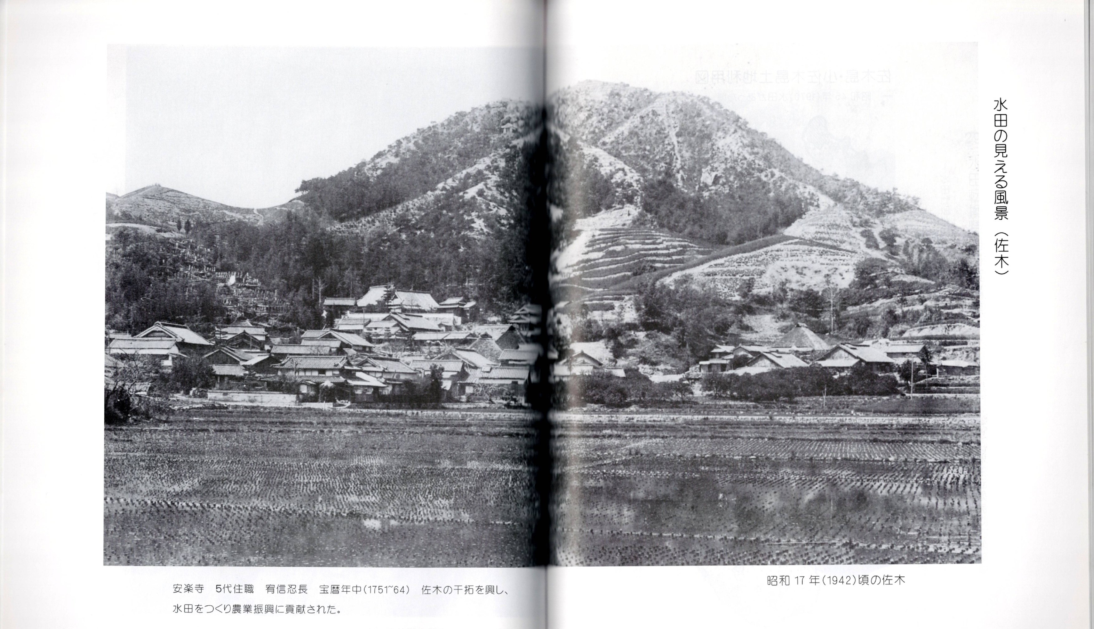
- Slope vulnerability is the downstream effect. Formerly farmed terrain, now lightly reforested with poplar and bamboo, has shallower roots and is more landslide-prone than when actively cultivated. 斜面の脆弱さは、その先に生じた影響である。 かつて耕されていた土地は、いまはポプラと竹でゆるやかに再生林化しており、根が浅いため、活発に耕されていた頃よりも崩れやすくなっている。
- The standing investigation into all of this is the Thirsty Island sub-project of the Sagishima Data Project; the modeling has begun but conclusions are not yet drawn. これらすべてをめぐる継続的な調査が、佐木島データ・プロジェクトのサブプロジェクト渇いた島である。モデル化は始まっているが、結論はまだ出ていない。
Related / 関連
- Research / The Thirsty Island (the active investigation) · Geography · Agriculture Today
Open questions / 未解決の問い
- The hydrological model itself is in progress; conclusions are not yet drawn. See open questions. 水文モデルそのものが進行中であり、結論はまだ出ていない。未解決の問いを参照。
The historical record / 歴史的な記録
The historical record deepens the "self-sufficient until imported water" framing above with specific dates, places, and methods, and refines the vague "1950s or 1960s" pipeline horizon in the Overview into a documented sequence. The classical-era facts (the Edo-era reservoir and drought records) and the tentative readings below should have native / historian review before formal use.
歴史的な記録は、上の「移入水が届くまで自給自足だった」という枠組みに、具体的な年代・場所・方法を加え、概要にある曖昧な「1950年代か1960年代」というパイプラインの時期を、記録に基づく一連の出来事へと精密化する。以下の近世(江戸期)の貯水池・干ばつ記録など古文書由来の事実、および暫定的な読みは、正式な使用の前に日本語母語話者・歴史家による確認を要する。
Why the island was thirsty / なぜ島は水に乏しかったか
The island's water scarcity was rooted in land use. Residents who had cleared slopes for salt-making prioritized creating arable land over replanting trees, so the mountains became bare, the land lost its water-retention capacity, and soil washed away in the rain (さぎしま讃歌 p.11).
島の水不足は土地利用に根ざしていた。製塩のために斜面を伐り開いた住民たちは、植林よりも耕地づくりを優先したため、山は禿げ、土地は保水力を失い、雨のたびに土が流れ出した(さぎしま讃歌 p.11)。
Because water was scarce, summer paddy work (weeding and keeping paddies watered) was very hard (さぎしま讃歌 p.38).
水が乏しかったため、夏の田仕事(草取りと田に水を保つこと)は非常につらかった(さぎしま讃歌 p.38)。
The haneki well-sweep / はね木(はねつるべ)
To draw water, wells were dug in many paddies and haneki (はね木) well-sweeps were erected; buckets (おけ) were used to draw water throughout the hot summer (さぎしま讃歌 p.38, p.42). A second source records that water was drawn twice daily, morning and evening, throughout the hot summer, with children working alongside adults (双鷺洲 p.262).
水を汲むため、多くの田に井戸が掘られ、はね木が立てられた。暑い夏を通じて、おけで水を汲んだ(さぎしま讃歌 p.38、p.42)。別の資料は、暑い夏のあいだ朝夕の一日二回水を汲み、子どもも大人とともに働いたと記す(双鷺洲 p.262)。
The haneki (はねつるべ, a well-sweep) used a lever principle: a bucket on one end of a pole and a counterweight stone on the other; the support post was made of a hard wood such as morogi (モロギ; reading TENTATIVE). The bucket was designed to be easily detached so it could be moved to the next paddy once one was finished; a split-bamboo pole tip held a plug, and a stone was tied on as the counterweight (さぎしま讃歌 p.42; corroborated 双鷺洲 p.262-263).
はね木(はねつるべ)はてこの原理を用いた。棹の一端におけ、他端に重し石を付け、支柱にはモロギ(読みは暫定)などの堅い木を使った。おけは取り外しやすく作られ、一つの田が終わると次の田へ移せた。割った竹の棹先に栓を仕込み、重しとして石を結わえた(さぎしま讃歌 p.42、双鷺洲 p.262-263が裏付ける)。
Erosion control and the rebuilding of water retention / 砂防と保水力の回復
Erosion-control (sabō) works were carried out and Kentucky bluegrass and lovegrass were planted; a monument as the "birthplace of erosion prevention" was built at the summit of Sagi Kazan (佐木火山; reading TENTATIVE), dated 1950 (Shōwa 25) in Sagishima Sanka (さぎしま讃歌 p.22). The companion source dates the same sand-control works and grass planting to 1951 (Shōwa 26) (双鷺洲 p.246). This one-year discrepancy between the two sources is flagged for reconciliation.
砂防工事が行われ、ケンタッキー・ブルーグラスとラブグラスが植えられた。「砂防発祥の地」の碑が佐木火山(読みは暫定)の山頂に建てられた。『さぎしま讃歌』は1950年(昭和25年)とする(さぎしま讃歌 p.22)。対する資料は同じ砂防工事と植草を1951年(昭和26年)とする(双鷺洲 p.246)。この二資料間の一年のずれは要照合として記録しておく。
Later, pine and hageshibari (ハゲシバリ, a deutzia / erosion-control shrub) were planted on the bald mountains; the hageshibari rooted deeply as it grew and unexpectedly increased groundwater (双鷺洲 p.249). This is a direct counterpoint to the existing page's note that today's shallow-rooted poplar-and-bamboo reforestation makes slopes more landslide-prone: the historical erosion-control planting was deliberately deep-rooting and water-restoring.
その後、禿げ山に松とハゲシバリ(ウツギ類の砂防低木)が植えられた。ハゲシバリは成長するにつれ深く根を張り、思いがけず地下水を増やした(双鷺洲 p.249)。これは、既存ページが記す「今日の根の浅いポプラと竹の再生林が斜面を崩れやすくしている」という指摘への直接の対比点である。歴史的な砂防植栽は、意図的に深く根を張り、保水力を回復させるものだった。
The arrival of imported water (refines the Overview) / 移入水の到来(概要を精密化)
A simple water supply (簡易水道, kan'i suidō) was installed for Mukōda (向田) and Sagi (佐木) in 1952 (Shōwa 27) (さぎしま讃歌 p.23; corroborated 双鷺洲 p.246). This is the documented start of piped supply and sits at the early edge of the existing page's "1950s or 1960s" horizon.
向田と佐木に簡易水道が引かれたのは1952年(昭和27年)である(さぎしま讃歌 p.23、双鷺洲 p.246が裏付ける)。これが記録上の水道供給の始まりであり、既存ページの「1950年代か1960年代」という時期の早い端にあたる。
Field irrigation reservoirs and facilities followed: a structure-improvement irrigation reservoir in 1970 (Shōwa 45) and field irrigation facilities in 1971 (Shōwa 46) (双鷺洲 p.247).
その後、灌漑施設が続いた。1970年(昭和45年)に構造改善の灌漑用貯水池、1971年(昭和46年)に田の灌漑施設が造られた(双鷺洲 p.247)。
In 1978 (Shōwa 53), undersea water supply to Kosagishima (小佐木島) became possible from the Sagi Shirikawa coast (佐木尻川海岸); a 1978 undersea water line from Sagi's Shirikawa reached all households (双鷺洲 p.121, p.123). This extends the imported-water story past the existing page's stated horizon: the full island, including Kosagishima, was not on a piped network until 1978.
1978年(昭和53年)、佐木尻川海岸から小佐木島への海底送水が可能になった。佐木尻川からの海底水道が全戸に届いた(双鷺洲 p.121、p.123)。これは移入水の物語を既存ページの想定する時期より先へ延ばす。小佐木島を含む島全体が水道網に接続されたのは、1978年になってからだった。
The Sunoue / Gō-shinkai reclaimed lowlands and flooding / 須ノ上・郷新開の干拓低地と水害
The mouth of the Sunoue River (須ノ上川, Sunoue-gawa) was a shallow beach that became sandy flats at low tide; during the Tenpō era (1830-1844) this beach was reclaimed (干拓) and turned into dry land, forming the Sunoue new-fields (新開, shinkai) (さぎしま讃歌 p.115).
須ノ上川の河口は浅い浜で、干潮時には砂州になった。天保年間(1830〜1844年)にこの浜が干拓され、陸地となって須ノ上の新開ができた(さぎしま讃歌 p.115)。
To prevent flood damage from heavy rains and seawater intrusion in Gō-shinkai (郷新開; reading TENTATIVE), a water-reservoir called akusu (あくす, a local term) was built with a sluice gate (水門, suimon) that drained accumulated water out at low tide (さぎしま讃歌 p.116).
郷新開(読みは暫定)での豪雨や海水の浸入による水害を防ぐため、「あくす」と呼ばれる貯水所が、干潮時に溜まった水を排出する水門とともに造られた(さぎしま讃歌 p.116)。
Because Gō-shinkai was originally low-lying land prone to water accumulation, it suffered some damage every year during typhoons or torrential rains, attributed partly to insufficient drainage; a major flood is documented in the Shōwa 20s (the 1950s) (さぎしま讃歌 p.116). This flooding at Gō-shinkai in Sunoue is recorded on the island (郷新開の水害(須ノ上)) (さぎしま讃歌 p.2-7).
郷新開はもともと水の溜まりやすい低地だったため、台風や豪雨のたびに毎年いくらかの被害を受けた。排水施設の不足も一因とされる。昭和20年代(1950年代)に大きな水害が記録されている(さぎしま讃歌 p.116)。須ノ上の郷新開の水害(郷新開の水害(須ノ上))は島の記録に残る(さぎしま讃歌 p.2-7)。
By 1974 (Shōwa 49), under the government's Paddy Field Conversion Special Measures Project, the Sunoue Gō-shinkai paddies were filled in (earth-banked), waterways were built between the fields, and the sluice-gate facilities were renovated, after which no significant flood damage was seen (さぎしま讃歌 p.116).
1974年(昭和49年)までに、国の田畑転換特別対策事業のもとで、須ノ上郷新開の田が埋め立てられ、田と田のあいだに水路が造られ、水門施設が改修された。それ以降、大きな水害は見られなくなった(さぎしま讃歌 p.116)。
On May 1 (year unstated in source) the damaged section of the district's Ōkawa embankment (大川堤防, Ōkawa teibō) was repaired and completed using stone and carried earth (双鷺洲 p.234).
五月一日(資料に年の記載なし)、地区の大川堤防の損壊部分が、石と運んだ土を用いて修復・完成された(双鷺洲 p.234)。
Edo-era reservoir and drought records (古文書 / classical sources) / 江戸期の貯水池・干ばつ記録
These entries derive from classical Japanese in Sōroshū and require native / historian review; several place-name readings are TENTATIVE.
以下の項目は『双鷺洲』中の古文(くずし字・近世文書)に由来し、日本語母語話者・歴史家の確認を要する。いくつかの地名の読みは暫定である。
During the 1823 (Bunsei 6) drought, drinking water on Okishima (沖嶋; reading TENTATIVE) ran out. Residents went to fetch water at Yuge-no-ba (ゆげの場; reading TENTATIVE) and Iwagi (岩城), but a strong east wind prevented it, and about sixty people (内六十人程) died of thirst (水二かつして死申也). Such an event was unprecedented, and it was recorded for that reason (双鷺洲 p.83). This death toll is a demographic claim from a classical source and should be cross-checked against the History pages before any population figure is drawn from it (conflicts-potential with existing demographic pages; HELD for reconciliation).
1823年(文政6年)の干ばつの折、沖嶋(読みは暫定)で飲み水が尽きた。住民はゆげの場(読みは暫定)や岩城へ水を汲みに行ったが、強い東風に阻まれ、内六十人程が「水二かつして死申也」(水に渇して死んだ)。前例のない出来事であり、そのために記録された(双鷺洲 p.83)。この死者数は古文書由来の人口に関わる記述であり、人口数値を導く前に歴史ページと突き合わせること(既存の人口ページと矛盾の可能性あり。要照合として保留)。
A sequence of reservoir sluice-gate (雨池樋) replacements and embankment works is recorded for the reservoirs Hara-amaike (原雨池; reading TENTATIVE) and Hiro-amaike (広雨池; reading TENTATIVE): an original Hara-pond sluice replacement in Kyōwa 3 (1803); works in Bunka 4, 11th month (1807; the source writes 又化四年); Bunka 8 (1811); Bunka 14 (1817); and Bunsei 3 (1820). Listed works include the Hara-amaike sluice replacement and inner dredging (内ラ掘), an embankment-top perimeter of 120 ken (土手天廻り百式十間), upper and lower sluice replacements at Hiro-amaike, the Yokuosae-shinkai sluice (横抑新開樋; reading TENTATIVE), and the Hara-pond sluice (原池樋) (双鷺洲 p.83).
原雨池(読みは暫定)と広雨池(読みは暫定)の雨池樋の仕替えと堤防工事の経過が記録されている。享和3年(1803年)の原池樋仕替、文化4年11月(1807年。資料は「又化四年」と記す)、文化8年(1811年)、文化14年(1817年)、文政3年(1820年)。記載された工事には、原雨池樋の仕替と内ラ掘、土手天廻り百式十間、広雨池の上下の樋仕替、横抑新開樋(読みは暫定)、原池樋が含まれる(双鷺洲 p.83)。
In Bunsei 3 (1820) a petition was submitted to the district guard office (郡方番役所) for sluice timber plus nails and clamps for the Hara-amaike (原雨池) reservoir; the order received was eighty 5-sun nails (釘大五寸八十本) and a number of clamps (かすがい; count unclear), received from the works office (双鷺洲 p.83).
文政3年(1820年)、原雨池の樋用材と釘・かすがいを求めて郡方番役所へ願い出た。受けた指示は釘大五寸八十本と、かすがい数(不明)で、作事方より受け取った(双鷺洲 p.83)。
In Bunsei 11 (1828) a petition was first submitted to replace the sluice gate (樋替) of Hiro-amaike (広雨池, the wide rain-reservoir); approval was granted and timber was sourced at Suha / Sunoue kushi-yama (須波 くし山; readings TENTATIVE) (双鷺洲 p.83). A related Bunsei 11 (1828) petition concerns replacing the sluice gate of Hironan-ike (広南池; reading TENTATIVE, likely the same 広雨池 Hiro-amaike) (双鷺洲 p.83-84).
文政11年(1828年)、広雨池の樋替を初めて願い出た。許可が下り、須波 くし山(読みは暫定)で用材が調達された(双鷺洲 p.83)。関連する文政11年(1828年)の願いは、広南池(読みは暫定、おそらく同じ広雨池)の樋替に関するものである(双鷺洲 p.83-84)。
The 1829 seaweed dispute and the Sagi crossing / 文政12年の藻草一件と佐木の渡し
These two entries are water-adjacent (the channel and the inshore waters) rather than hydrology proper; they are noted here for the water/sea context and may belong better on a Fishing or Place page.
以下の二項目は、水文そのものよりも水・海に隣接する事柄(瀬戸と沿岸の海)である。水・海の文脈のためにここに記すが、漁業ページや地理ページに置く方が適切かもしれない。
In Bunsei 12 (1829) a seaweed dispute occurred (per the Sagishima sōkusa ikkensho / 佐木島藻草一件書, reading TENTATIVE, in the Mukōda-noura Nishihara family documents 向田野浦・西原家文書): people from Mukōda (向田) crossed the boundary at Hokoya (ほこや; reading TENTATIVE) to harvest amamo (甘藻, eelgrass) in Suwa-village Sagi waters (須波村佐木). After a complaint via the kumigashira, Mukōda-noura agreed to stop, but on the 16th day seven or eight seaweed-gathering boats again crossed over (双鷺洲 p.101-102, quoting 「佐木島藻草一件書」(向田野浦・西原家文書) and 三原市史).
文政12年(1829年)、藻草一件が起きた(向田野浦・西原家文書の「佐木島藻草一件書」(読みは暫定)による)。向田の者がほこや(読みは暫定)の境を越え、須波村佐木の海で甘藻を刈った。組頭を通じた苦情ののち、向田野浦は中止に同意したが、16日に再び藻刈り舟七、八艘が越えてきた(双鷺洲 p.101-102。「佐木島藻草一件書」(向田野浦・西原家文書)および三原市史を引用)。
During that dispute, when Sagi farmers went to negotiate they were resisted: men from Mukōda's seaweed boats chased them with weapons, smashed the village's takabari lantern (高張提灯), and seriously injured one Sagi farmer in the head (knocking him unconscious). The men also forced into the kumigashira's house, used violent language, and damaged cotton crops on the way back (双鷺洲 p.102, quoting 三原市史).
その一件の最中、佐木の百姓が交渉に行くと抵抗にあった。向田の藻刈り舟の者たちが得物を持って追い、村の高張提灯を打ち壊し、佐木の百姓一人の頭を重く傷つけた(気を失わせた)。者たちは組頭の家にも押し入り、乱暴な言葉を使い、帰り道に綿の作物を荒らした(双鷺洲 p.102。三原市史を引用)。
The crossing to Sagi was about 300 [unit garbled in source: ken / meters] across the Egama Channel (柄鎌の瀬戸; reading TENTATIVE), made in small private hand-rowed wooden farm-boats. The channel, also called the Nanase Channel (七瀬の瀬戸), is one of the Inland Sea's seven swift currents, with fast tides that swept the rowed boats, making crossings constantly dangerous (双鷺洲 p.124).
佐木への渡しは、柄鎌の瀬戸(読みは暫定)を約300[資料の単位不明:間/メートル]渡るもので、私有の小さな手漕ぎの農舟で行われた。この瀬戸は七瀬の瀬戸とも呼ばれ、瀬戸内海の七つの急流の一つで、速い潮が漕ぎ舟を流し、渡海は常に危険だった(双鷺洲 p.124)。
Notes for reconciliation / 要照合の覚書
- The Overview's "1950s or 1960s" pipeline horizon should be refined to: simple water supply at Mukōda and Sagi in 1952, and undersea supply to Kosagishima in 1978 (the whole island was not piped until 1978). 概要の「1950年代か1960年代」という水道の時期は、向田・佐木の簡易水道(1952年)と小佐木島への海底送水(1978年)に精密化すべきである(島全体が水道化したのは1978年)。
- The existing page treats reforestation as uniformly shallow-rooted and landslide-prone; the 双鷺洲 p.249 record of deep-rooting hageshibari increasing groundwater is a contrasting historical data point worth integrating. 既存ページは再生林を一様に「根が浅く崩れやすい」と扱うが、双鷺洲 p.249のハゲシバリが深く根を張り地下水を増やしたという記録は、対照的な歴史的データであり統合する価値がある。
- 1950 vs 1951 erosion-control date discrepancy between さぎしま讃歌 p.22 and 双鷺洲 p.246: HELD for reconciliation. 砂防の年(1950年対1951年)が さぎしま讃歌 p.22 と 双鷺洲 p.246 で食い違う。要照合として保留。
- The 1823 "about sixty people died of thirst" figure is a classical-source demographic claim; HELD for reconciliation against History/demographic pages. 1823年の「内六十人程が渇死」は古文書由来の人口記述。歴史・人口ページとの要照合として保留。
Sources / 出典
- Sagishima Data Project page; Foundation Welcome. See bibliography. 佐木島データ・プロジェクトのページ、財団のウェルカム資料。参考文献を参照。