draft
Ports and Landing / 港と上陸地点と浜辺
Overview / 概要
Sagishima has several ports. The Foundation's primary one is Sunoue Port (須ノ上港), in the northern district where Kakumeisha stands. Sagi Port (鷺港) in the south is the historic main port, used by some ferry routes. The Foundation's stationery and customs address is Mukōtanoura (向田野浦): 〒723-0022 広島県三原市鷺浦町向田野浦5008-3.
佐木島にはいくつかの港がある。財団が主に使うのは、格明舎が建つ北部の地区にある須ノ上港である。南部の鷺港は歴史的な主要港で、一部のフェリー航路が利用している。財団の事務・通関上の住所は向田野浦:〒723-0022 広島県三原市鷺浦町向田野浦5008-3。
What we know / わかっていること
- From Onomichi: the standard ferry departs Onomichi Port around midday and arrives Sunoue Port a little over twenty minutes later. Kakumeisha is a few minutes' walk from Sunoue Port. 尾道から:通常のフェリーは正午頃に尾道港を出航し、20分余りで須ノ上港に着く。格明舎は須ノ上港から徒歩数分の距離にある。
- Reaching Onomichi by Shinkansen: take the Shinkansen to Fukuyama, then transfer to a local train to Onomichi Station (you can buy both tickets together at the boarding counter). The destination is Onomichi Station, not the more distant Shin-Onomichi Station. 新幹線で尾道へ:新幹線で福山まで行き、在来線に乗り換えて尾道駅へ向かう(乗車する駅の窓口で両方の切符をまとめて購入できる)。目的地は尾道駅であり、離れた場所にある新尾道駅ではない。
- From Mihara: the island is also reached from Mihara, close to Shinkansen Mihara Station, in roughly 13 to 15 minutes by ferry or speed vessel (per 373.farm and the NOT A HOTEL SETOUCHI access notes). This makes Sagishima unusually close to a Shinkansen station for a bridge-less island. Sagi Port (鷺港) in the south takes some of these routes. 三原から:新幹線の三原駅に近い三原からも、フェリーまたは高速船でおよそ13〜15分で島に渡れる(373.farm およびノットアホテル瀬戸内のアクセス案内による)。橋のかかっていない島としては、佐木島は新幹線駅に異例なほど近い。これらの航路の一部は南部の鷺港を発着する。
- Sunoue Beach (須ノ上ビーチ) is the sandy stretch in front of the former Sunoue Elementary School building, two minutes from Sunoue Port. It hosts the Foundation's larger gatherings: spring hanami, summer beach meals, the post-studio party at the end of each major program. (Daily cohort meals happen instead between Tsumiki and Itaru houses; the beach is for public-facing events.) 須ノ上ビーチは、旧須ノ上小学校の校舎前に広がる砂浜で、須ノ上港から徒歩2分。財団の大きな集まりの場となっている。春の花見、夏の浜辺での食事、各主要プログラムの終わりに開かれるスタジオ後のパーティーなどである。(日々の受講生の食事はこれとは別に積木の家と伊太留の家のあいだで行われる。浜辺は対外的な催しのための場所である。)
- Onomichi is kin, not just adjacent. The Onomichi Akiya Saisei Project (尾道空き家再生プロジェクト) does closely related work; its Anago No Nedoko (あなごのねどこ) hostel and renovated houses (Ma, the Gaudi House) parallel the Workshop's practice. Treat an Onomichi stay en route as part of the Foundation's working geography, not tourism. (See Neighbors and Region.) 尾道は単なる隣接地ではなく、同族である。尾道空き家再生プロジェクトは密接に関連した活動を行っており、その「あなごのねどこ」ゲストハウスや改修された住宅(Ma、ガウディハウス)は、ワークショップの実践と通じ合うものがある。途中で尾道に滞在することは観光ではなく、財団が活動する地理の一部として捉えてほしい。(近隣と地域を参照。)
- Dosojin Hill (道祖神の丘), named for the dōsojin boundary-deity statues along old paths, is a hanami spot and a point the 88+α route winds through. 道祖神の丘は、古い道沿いに立つ境界の神「道祖神」の石像にちなんで名づけられた場所で、花見の名所であり、88+α 御遍路の道がうねりながら通る一点でもある。
- One store, cash only. The island's single small shop is the JA Store (JAストア), closer to a rural gas-station mini-mart than a convenience-store chain (good for side dishes, cold drinks, ice cream, beer, and humble snacks), plus vending machines. Credit cards are not accepted anywhere on the island, so bring yen for anything you need here. A telling measure of the island's small, aging population. 店は一軒、現金のみ。島で唯一の小さな店はJAストアで、コンビニチェーンというより田舎のガソリンスタンドの売店に近い(惣菜、冷たい飲み物、アイス、ビール、ささやかな菓子に向く)。ほかに自動販売機がある。島内ではどこでもクレジットカードが使えないため、必要なものには現金(円)を用意すること。島の小さく高齢化した人口を物語る一つの目安である。
Historical record: ports, piers, and roads / 歴史的記録:港・桟橋・道路
The four piers and the island's harbors / 四つの桟橋と島の港
Four main landing structures are recorded on the island: the Sagi Port pier (さぎ港桟橋), the Sunoue Agricultural Cooperative (須ノ上農協) with its own port and pier, the Sagi Agricultural Cooperative (佐木農協) and its pier, and the old Mukōda pier (向田旧桟橋). (さぎしま讃歌 p.2-7) 島には四つの主要な上陸施設が記録されている。さぎ港桟橋、独自の港と桟橋を持つ須ノ上農協、佐木農協とその桟橋、そして向田旧桟橋である。(さぎしま讃歌 p.2-7)
A Hōreki-era list (宝暦年間, 1751-1764) of ura (coastal inlet places) records 20 ura in Toyota district (豊田郡), of which 14 were "main ura" (本浦) and 6 were "attached ura" (附浦). The named places include Mukōda-no-ura (向田之浦), Sunami-ura (角南浦, reading TENTATIVE), Sunoue-ura (須上浦), Setoda-ura (瀬戸田浦), and the islands Sagishima (佐木島) and Ikuchijima (生口島), among others. (双鷺洲 p.84, citing the classical ura list) [Classical-source reading; needs historian review.] 宝暦年間(1751-1764)の浦の一覧は、豊田郡に二十の浦を記録し、うち十四が本浦、六が附浦であったとする。記載地名には向田之浦、角南浦(読みは暫定)、須上浦、瀬戸田浦、また佐木島・生口島などの島がある。(双鷺洲 p.84、古典的な浦の一覧による)〔古典資料に基づく読み。歴史家による確認が必要。〕
Local ura place-names are also noted as probable old boat anchorages (舟泊り): Kosagishima Kita-ura (小佐木の北浦), Sagi's Ko-ura (佐木の小浦) and Ōno-ura (大野浦), and Mukōda's Mukōda-ura (向田の向田浦). Legend holds that Empress Jingū (神功皇后) moored her ship at Kosagishima's Kita-ura, thought to have been an anchorage since ancient times. (双鷺洲 p.84, the Kita-ura reference citing Nihon no Chimei / 日本の地名) [Legendary material; flagged for review.] 地元の浦の地名も、古い舟泊りであった可能性があるものとして挙げられている。小佐木の北浦、佐木の小浦と大野浦、向田の向田浦である。神功皇后が小佐木の北浦に船を泊めたという伝承があり、ここは古くからの舟泊りと考えられている。(双鷺洲 p.84、北浦の記述は『日本の地名』を引用)〔伝承資料。確認待ち。〕
Mukōda port (向田港) was historically the "main ura" (本浦). Once deep, its waters had shoaled with sediment carried by the Ōhira river (大平川, reading TENTATIVE), so that as of 2015 large vessels could no longer easily enter and leave. (双鷺洲 p.84) The inlet of Mukōda harbor was formerly a narrow strait holding a boat-mooring spot (舟泊まり); the Warei-ishi Jizō (和霊石地蔵, reading TENTATIVE) sits near the mouth of this strait, carved at the waterline, so that at low tide the whole figure is exposed, at high tide it submerges to the shoulders, and at spring tide (大潮) it submerges completely. (双鷺洲 p.173) 向田港は歴史的に本浦であった。かつては水深があったが、大平川(読みは暫定)が運ぶ土砂で浅くなり、2015年時点で大型船は容易に出入りできなくなっていた。(双鷺洲 p.84) 向田港の入り江はかつて舟泊まりを抱える狭い瀬戸であり、和霊石地蔵(読みは暫定)はこの瀬戸の口近く、水際に彫られている。干潮時には全身が現れ、満潮時には肩まで沈み、大潮には完全に水没する。(双鷺洲 p.173)
Transport by sea, before the roads / 道路以前、海による輸送
Before land transport was established on Sagishima, all agricultural products shipped to the agricultural cooperative (農協) were moved by sea; produce was loaded onto boats for transport. (さぎしま讃歌 p.87, p.182; 双鷺洲 p.182 corroborates) 佐木島に陸上輸送が確立される以前、農協へ出荷される農産物はすべて海路で運ばれ、産品は舟に積み込まれて輸送された。(さぎしま讃歌 p.87, p.182)
Small boats called tenma (てんま) ferried between ships anchored offshore at Sunoue and the land. There used to be many sailing vessels (帆の船, ho no fune) anchored off Sunoue; after the war these were replaced by larger ships. (さぎしま讃歌 p.154) 須ノ上沖に停泊する船と陸との間は、てんまと呼ばれる小舟で行き来した。かつて須ノ上沖には帆の船が多く停泊していたが、戦後は大型船に取って代わられた。(さぎしま讃歌 p.154)
The island-circuit road / 島内一周道路
In Shōwa 7 (1932), construction began on an island-circuit road (島内一周道路) as relief / public-works employment. (さぎしま讃歌 p.16; 双鷺洲 p.245 describes it as a national project) [The relief-work term is given as 匤救事業 / 匤救 = kyōkyū jigyō, reading TENTATIVE.] 昭和7年(1932)、島内一周道路の建設が、救済・公共事業として始まった。(さぎしま讃歌 p.16;双鷺洲 p.245 は国の事業と記す)〔救済事業の語は匤救事業=きょうきゅうじぎょう、読みは暫定。〕
Until Shōwa 25 (1950), the island's only prefectural road was the east-loop line (東廻り線) running through Mukōda, Sunoue, and Sagi (向田・須ノ上・佐木). (さぎしま讃歌 p.98; 双鷺洲 p.245-246) 昭和25年(1950)まで、島で唯一の県道は向田・須ノ上・佐木を通る東廻り線であった。(さぎしま讃歌 p.98;双鷺洲 p.245-246)
In Shōwa 25 (1950), the west-loop line (Mukōda-Sagi, 西廻り線) was approved as a prefectural road. To prepare it, Mukōda district widened the Warei-ishi Jizō village road and Sagi district widened the Magoshi village road (馬越, reading TENTATIVE) to 6 shaku by donation and volunteer labor; stones were laid along the Kō-no-kami / Saiwai-no-kami coast (幸ノ神海岸, reading TENTATIVE). A loan was received from the Ministry of Posts (郵政省), and the west-loop line received the designation Prefectural Road No. 361 (県道361号線). (さぎしま讃歌 p.22, p.98; 双鷺洲 p.245-246) Development of the Warei-ishi Jizō village road (里道) had begun around Shōwa 23 (c. 1948). (さぎしま讃歌 p.99, p.100, p.101) 昭和25年(1950)、西廻り線(向田-佐木)が県道として認可された。これに備え、向田地区は和霊石地蔵の里道を、佐木地区は馬越(読みは暫定)の里道を、寄付と勤労奉仕で六尺幅に拡張し、幸ノ神海岸(読みは暫定)に石を敷いた。郵政省から借入を受け、西廻り線は県道361号線に指定された。(さぎしま讃歌 p.22, p.98;双鷺洲 p.245-246) 和霊石地蔵の里道の整備は昭和23年(およそ1948)頃に始まっていた。(さぎしま讃歌 p.99, p.100, p.101)
In Shōwa 26 (1951), work began on the west-loop line, creating a flat road along the coast behind the Warei-ishi Jizō. Sagiura Village purchased Sagiura's first three-wheeled auto-truck (自動三輪車) around this time, and lifestyle change and farm mechanization began. (さぎしま讃歌 p.23, p.98) In Shōwa 27 (1952), the Warei-ishi Jizō road section of the west-loop prefectural road was repaired. (さぎしま讃歌 p.24, p.99; 双鷺洲 p.247) 昭和26年(1951)、西廻り線の工事が始まり、和霊石地蔵の裏手の海岸沿いに平坦な道ができた。鷺浦村はこの頃、佐木浦初の自動三輪車を購入し、生活の変化と農業の機械化が始まった。(さぎしま讃歌 p.23, p.98) 昭和27年(1952)、西廻り県道の和霊石地蔵道の区間が補修された。(さぎしま讃歌 p.24, p.99;双鷺洲 p.247)
A photo dated around Shōwa 10 (1935) shows the area around the Warei-ishi Jizō before the road was built. (さぎしま讃歌 p.96, caption: 昭和10年頃の和霊石地蔵周辺) 昭和10年(1935)頃の写真は、道路ができる前の和霊石地蔵周辺を写している。(さぎしま讃歌 p.96、写真説明:昭和10年頃の和霊石地蔵周辺)
The road that was originally only an east-loop line, later joined by a west-loop line, became a daily-life road looping the whole island; the formerly one-lane prefectural road has since been widened into a two-lane road with sidewalks. (さぎしま讃歌 p.182) もともと東廻り線のみだった道は、のちに西廻り線が加わり、島全体を周回する生活道路となった。かつて一車線だった県道は、その後、歩道付きの二車線道路に拡幅された。(さぎしま讃歌 p.182)
In Shōwa 46 (1971), work began on Kosagishima's farm road (completed Shōwa 49 / 1974). (双鷺洲 p.247) In Shōwa 48 (1973), the Nanase (七瀬, reading TENTATIVE) farm-road improvement project began (completed across Shōwa 48-60 / 1973-1985). (双鷺洲 p.248) 昭和46年(1971)、小佐木島の農道工事が始まった(昭和49年/1974完成)。(双鷺洲 p.247) 昭和48年(1973)、七瀬(読みは暫定)の農道整備事業が始まった(昭和48-60年/1973-1985にわたり完成)。(双鷺洲 p.248)
The piers, ward by ward / 桟橋、地区ごと
Three-ward floating piers, Shōwa 26 (1951). A drag-net sailing boat (うたせ舟, utase-bune) was purchased and remodeled from Yokoshima (横島), and floating piers were installed in all three wards (三区とも) of Sagishima. (さぎしま讃歌 p.22, p.148, p.155; 双鷺洲 p.246) 三区の浮桟橋、昭和26年(1951)。横島からうたせ舟を購入・改造し、佐木島の三区すべてに浮桟橋を設置した。(さぎしま讃歌 p.22, p.148, p.155;双鷺洲 p.246)
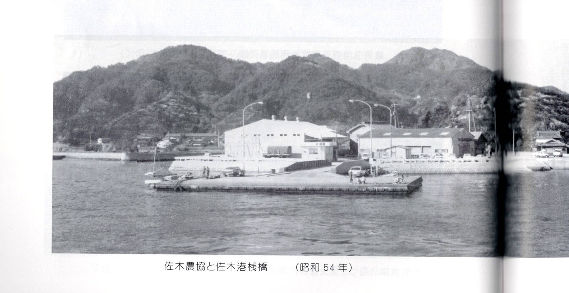
Sagi Port (佐木港). [See conflict note below re: 佐木港 vs the existing page's 鷺港.] In Shōwa 34 (1959) the Sagi Port pier was rebuilt as a reinforced-concrete floating pier. (さぎしま讃歌 p.148) Passenger ferry service began in Shōwa 38 (1963). (さぎしま讃歌 p.148) An unloading / cargo-landing yard (荷揚げ場) was built at the Sagi inner harbor (佐木内港) in Shōwa 46 (1971). (さぎしま讃歌 p.148) Reclamation of the Sagi inner-harbor wharf (佐木内港埠頭) began in Shōwa 44 (1969); by Shōwa 54 (1979) a reinforced-concrete ferry pier had been built. (さぎしま讃歌 p.148) In Shōwa 55 (1980) the Sagi Port passenger waiting area (乗客待合所) and the South Breakwater (南防波堤) were built. (さぎしま讃歌 p.148) In Shōwa 60 (1985) a detached straight-line "ichimonji" breakwater (一文字防波堤) was built. (さぎしま讃歌 p.148) The Sagi Agricultural Cooperative (佐木農協) was relocated and rebuilt over time as the pier was installed and expanded. (さぎしま讃歌 p.148) 佐木港。〔佐木港と既存ページの鷺港について、下記の矛盾注記を参照。〕昭和34年(1959)、佐木港の桟橋は鉄筋コンクリートの浮桟橋に建て替えられた。(さぎしま讃歌 p.148) 昭和38年(1963)、旅客フェリーの運航が始まった。(さぎしま讃歌 p.148) 昭和46年(1971)、佐木内港に荷揚げ場が築かれた。(さぎしま讃歌 p.148) 佐木内港埠頭の埋立は昭和44年(1969)に始まり、昭和54年(1979)までに鉄筋コンクリートのフェリー桟橋ができた。(さぎしま讃歌 p.148) 昭和55年(1980)、佐木港の乗客待合所と南防波堤が築かれた。(さぎしま讃歌 p.148) 昭和60年(1985)、一文字型の離岸防波堤が築かれた。(さぎしま讃歌 p.148) 桟橋の設置と拡張に伴い、佐木農協は時とともに移転・改築された。(さぎしま讃歌 p.148)
As of the early 2010s, leisure boats docked at Sagi Port rather than the old farm boats (藻とり舟, motori-bune, seaweed-gathering boats), and the former unloading area was used as a parking lot for commuters' passenger cars. (さぎしま讃歌 p.184) 2010年代初頭の時点では、佐木港にはかつての藻とり舟ではなくレジャーボートが停泊し、かつての荷揚げ場は通勤者の乗用車の駐車場として使われていた。(さぎしま讃歌 p.184)
Sunoue Port (須ノ上港). The completion ceremony (竣工式) for the Sunoue Port pier was held in Shōwa 37 (1962), when a reinforced-concrete floating pier and a waiting room were built. (さぎしま讃歌 p.152) 須ノ上港。須ノ上港桟橋の竣工式は昭和37年(1962)に行われ、鉄筋コンクリートの浮桟橋と待合室が築かれた。(さぎしま讃歌 p.152)
Mukōda pier (向田桟橋). The old Mukōda pier (向田旧桟橋) stood in the inner harbor south of the present pier. (さぎしま讃歌 p.155) In Shōwa 36 (1961) the Mukōda pier was rebuilt as a reinforced-concrete pier. (さぎしま讃歌 p.155) In Shōwa 48 (1973) it was moved to the right side of the Warei-ishi Jizō (和霊石地蔵). (さぎしま讃歌 p.155) 向田桟橋。向田旧桟橋は現在の桟橋より南の内港にあった。(さぎしま讃歌 p.155) 昭和36年(1961)、向田桟橋は鉄筋コンクリートの桟橋に建て替えられた。(さぎしま讃歌 p.155) 昭和48年(1973)、和霊石地蔵の右側へ移された。(さぎしま讃歌 p.155)
Earlier still, from October 15 to 23 of Meiji 43 (1910), the Mukōda-Nora / Koya landing place (荷場, niba) and its channel (澪, mio) were greatly repaired: the landing place expanded by 30 units and the channel lengthened by 120 ken; a completion ceremony was held on the 27th with sumo to encourage the youth. (双鷺洲 p.235) [Place-name 向田野浦胡谷 = Mukōda Nora Koya, reading TENTATIVE.] さらに古く、明治43年(1910)10月15日から23日にかけて、向田野浦胡谷の荷場と澪が大きく修復された。荷場は三十(単位)拡張され、澪は百二十間延長された。27日に竣工式が行われ、若者を励ますため相撲が催された。(双鷺洲 p.235)〔地名 向田野浦胡谷=むこうだのうらこや、読みは暫定。〕
Kosagishima crossing and the school commute / 小佐木島の渡しと通学
The Kosagi lighthouse (小佐木灯台) was built in Meiji 27 (1894). (双鷺洲 p.119) At the foot of the lighthouse on the Sagi side stands Kotohira-sha (金刀比羅社), enshrining Ōmononushi-no-mikoto (大物主命). (双鷺洲 p.207) 小佐木灯台は明治27年(1894)に建てられた。(双鷺洲 p.119) 佐木側の灯台の麓には、大物主命を祀る金刀比羅社が建つ。(双鷺洲 p.207)
School transport across the fast-flowing strait was originally done in small private boats, with parents taking turns at the helm. Children could not go home freely after school; they waited at a waiting area, shouting toward Kosagishima and waving flags for pickup. (さぎしま讃歌 p.170) Because boat service to Mihara was only one or two round trips a day at the school's founding (Shōwa 22 / 1947), non-local teachers were stationed dispersed across the three districts to supervise students with each elementary school. (双鷺洲 p.215, citing 鷺浦中学校創立五十周年記念誌) 流れの速い瀬戸を渡る通学は、もともと親が交代で舵を取る小さな個人の舟で行われた。子どもたちは放課後に自由に帰れず、待合所で待ち、小佐木島に向かって叫び、旗を振って迎えを呼んだ。(さぎしま讃歌 p.170) 学校創立時(昭和22年/1947)、三原への船は一日に一、二往復しかなかったため、島外の教員は三区に分散して配置され、各小学校と共に生徒を監督した。(双鷺洲 p.215、『鷺浦中学校創立五十周年記念誌』を引用)
In Shōwa 34 (1959), Mihara City launched the 2-ton school commuter ferry Shirasagi-maru (しらさぎ丸), temporarily ending the use of private boats. (さぎしま讃歌 p.170) That same year, a reinforced-concrete floating pier (浮桟橋) was built at Kosagi inner port, at a total construction cost of 6,180,000 yen. (双鷺洲 p.120) 昭和34年(1959)、三原市は2トンの通学渡船しらさぎ丸を就航させ、個人の舟の使用は一時的に終わった。(さぎしま讃歌 p.170) 同年、小佐木内港に鉄筋コンクリートの浮桟橋が、総工費618万円で築かれた。(双鷺洲 p.120)
A Kosagishima Commuter-Ferry Construction Promotion Alliance (小佐木通学渡船建造期成同盟 / 同盟会) was formed to obtain a boat adequate for the four commuting students (elementary, junior-high, and high-school). (さぎしま讃歌 p.170; 双鷺洲 p.120, p.124) With a city subsidy, a second-generation Shirasagi-maru was built: a 4.8-ton vessel with an 8-horsepower diesel engine, after which problems gradually improved. (さぎしま讃歌 p.170; 双鷺洲 p.124 gives 4.8 tons, p.120 gives "4 tons")
[DATE DISCREPANCY, flagged, not resolved] The launch year of the second-generation Shirasagi-maru disagrees across the sources: - さぎしま讃歌 p.170: Japanese gives 昭和44年 (= 1969), but the parenthetical and the book's English both say 1967. - 双鷺洲 p.124: 昭和42年(1967). - 双鷺洲 p.120 heading: prints 昭和44年(1967), but Shōwa 44 = 1969. Held for reconciliation; native/historian review recommended.
四人の通学生(小・中・高)に十分な船を得るため、小佐木通学渡船建造期成同盟(同盟会)が結成された。(さぎしま讃歌 p.170;双鷺洲 p.120, p.124) 市の補助を得て、二代目しらさぎ丸が建造された。8馬力ディーゼル機関を備えた4.8トンの船で、これにより問題は次第に改善した。(さぎしま讃歌 p.170;双鷺洲 p.124 は4.8トン、p.120 は「4トン」とする)
〔年代の不一致, 要確認、未解決〕二代目しらさぎ丸の就航年は資料間で食い違う。さぎしま讃歌 p.170 は本文に昭和44年(=1969)とあるが、括弧書きと英語はともに1967とする。双鷺洲 p.124 は昭和42年(1967)。双鷺洲 p.120 の見出しは昭和44年(1967)と印刷するが、昭和44年=1969。要確認とし、ネイティブ・歴史家の確認を推奨する。
In Shōwa 48 (1973), a commuter-ferry waiting shelter (通学渡船待合所) was completed, and that same year the people of Sagiura petitioned Mihara City as one body for further improvement of the commute. (さぎしま讃歌 p.171; 双鷺洲 p.120) In Shōwa 52 (1977), a reclaimed reinforced-concrete ferry pier was installed at the Kosagi inner wharf (小佐木内埠頭). (双鷺洲 p.121) 昭和48年(1973)、通学渡船待合所が完成し、同年、鷺浦の人々は一体となって三原市に通学事情のさらなる改善を陳情した。(さぎしま讃歌 p.171;双鷺洲 p.120) 昭和52年(1977)、小佐木内埠頭に埋立式の鉄筋コンクリートのフェリー桟橋が設置された。(双鷺洲 p.121)
The donated ferry, 1999-2005 / 寄贈されたフェリー、1999-2005
In Heisei 11 (1999), the ferry on the Mukōda-Kosagishima-Mihara route (the Kōun-maru, 幸運丸) stopped calling at Kosagi port, making regular scheduled service a major problem between Mihara City and Kosagishima residents. (さぎしま讃歌 p.172; 双鷺洲 p.121, p.125) 平成11年(1999)、向田-小佐木島-三原航路のフェリー(幸運丸)が小佐木港への寄港を取りやめ、定期運航が三原市と小佐木島住民の間で大きな問題となった。(さぎしま讃歌 p.172;双鷺洲 p.121, p.125)
That same year, Ōmori Hiroo (大森博夫, then 71), a Kosagishima native and Kure City (呉市) resident who ran a transport company, provided a ferryboat (双鷺洲 p.125 says he purchased it for about 3,000,000 yen). Islanders self-managed a service of four round trips a day between Kosagishima and Mihara that could carry both people and vehicles, to the residents' great gratitude. (さぎしま讃歌 p.172; 双鷺洲 p.125) [Name reading 大森博夫 = Ōmori Hiroo, TENTATIVE; 双鷺洲 prints a garbled "(7)" after his name.] 同年、小佐木島出身で呉市に住み、運送会社を営む大森博夫(当時71歳)がフェリーを提供した(双鷺洲 p.125 は約300万円で購入したとする)。島民は自主運営で、小佐木島-三原間を一日四往復、人も車も運べる便を走らせ、住民に大いに感謝された。(さぎしま讃歌 p.172;双鷺洲 p.125)〔人名 大森博夫=おおもり ひろお、読みは暫定。双鷺洲 は名の後に文字化けの「(7)」を印刷。〕
The donated ferry service was discontinued on December 14, Heisei 17 (2005), owing to soaring fuel prices and other rising costs that made self-operation difficult; it had run from 1999 to 2005. (さぎしま讃歌 p.172; 双鷺洲 p.125) 寄贈されたフェリーの運航は、燃料価格の高騰などにより自主運営が困難となり、平成17年(2005)12月14日に終了した。運航期間は1999年から2005年までであった。(さぎしま讃歌 p.172;双鷺洲 p.125)
As of 2015, a high-speed boat (高速船) on the Mihara-Setoda (三原-瀬戸田) round trip called at the port. (さぎしま讃歌 p.172; 双鷺洲 p.125) 2015年時点では、三原-瀬戸田を往復する高速船が寄港していた。(さぎしま讃歌 p.172;双鷺洲 p.125)
Mail and the post office / 郵便と郵便局
As of Shōwa 48 (1973), two postal clerks came by mail boat from the Sunami Post Office (須波郵便局), splitting into a Sagi/Sunoue section and a Mukōda section to collect and deliver mail. (さぎしま讃歌 p.165) The Mihara Sagiura Post Office (三原鷺浦郵便局) was relocated and newly built in Shōwa 60 (1985), to the west side of the Sagishima Furusato-kan (さぎしまふるさと館, heritage hall). (さぎしま讃歌 p.188) 昭和48年(1973)時点では、二人の郵便局員が須波郵便局から郵便船で来て、佐木・須ノ上の係と向田の係に分かれて集配を行った。(さぎしま讃歌 p.165) 三原鷺浦郵便局は昭和60年(1985)に、さぎしまふるさと館の西側に移転新築された。(さぎしま讃歌 p.188)
Around Sagi Port today: parks and shoreline / 現在の佐木港周辺:公園と海岸
In Heisei 10 (1998), amid advancing depopulation and seeking revitalization, "Minato-no-Oka Park" (さぎしまみなとの丘公園 / 港の丘公園) was created on a small hill facing Sagi Port; the proposal to plant cherry trees on the hill's fallow land came from Okamoto Chiyoki (岡本千代喜) of the Sagi greening / flower society (緑花会, Ryokukakai) as community-building. Cherry trees were planted there and on the embankment of a former salt-field site (塩田跡地堤防) nearby, forming a walking path for enjoying blossoms. (さぎしま讃歌 p.191; 双鷺洲 p.116) 平成10年(1998)、進む過疎の中で活性化を求めて、佐木港に面する小さな丘に「さぎしまみなとの丘公園」がつくられた。丘の休耕地に桜を植える提案は、佐木の緑花会の岡本千代喜による地域づくりであった。桜はその丘と、近くの塩田跡地の堤防に植えられ、花を楽しむ散策路となった。(さぎしま讃歌 p.191;双鷺洲 p.116)
In Shōwa 55 (1980) the Sagi Ōnoura area was designated the Sagi Ōnoura Natural Seashore Preservation District (佐木大野浦自然海浜公園) under the Natural Seashore Preservation Ordinance (自然海浜保全条例), to keep the beach available for swimming; in Heisei 15 (2003) it was developed as a seaside / bathing park. (さぎしま讃歌 p.191) 昭和55年(1980)、佐木大野浦一帯は、海水浴の場を保つため、自然海浜保全条例のもとで佐木大野浦自然海浜公園に指定された。平成15年(2003)には海浜・海水浴公園として整備された。(さぎしま讃歌 p.191)
Monuments and youth labor / 記念碑と勤労奉仕
A commemorative-project monument stands at Sagi Port (佐木港). Its inscription reads "Kōki 2600 Commemorative Project Monument" (皇紀2600年記念事業), the work begun in October Shōwa 13 (1938) and completed November Shōwa 15 (1940), through the service of the Sagiura Village men's and women's youth association, Sagiura branch (鷺浦村男女青年団鷺浦分団). (双鷺洲 p.237, monument inscription) The Kōki 2600 commemorative projects completed by youth volunteer labor are summarized as: Sagi Port revetment / reclamation (佐木港護岸埋立), afforestation around Enokidani Pond / New Pond (榎木谷池), and the reclamation of Shikada (鹿田, reading TENTATIVE; written both 志加田 and 鹿田 in the source). (双鷺洲 p.240) 佐木港には記念事業の碑が立つ。碑文は「皇紀2600年記念事業」とあり、昭和13年(1938)10月に始まり、昭和15年(1940)11月に、鷺浦村男女青年団鷺浦分団の奉仕によって完成した。(双鷺洲 p.237、碑文) 青年の勤労奉仕で完成した皇紀2600年記念事業は、佐木港の護岸埋立、榎木谷池(新池)周辺の植林、志加田/鹿田の埋立とまとめられる。(双鷺洲 p.240)〔鹿田の読みは暫定。原典は志加田と鹿田の両表記を用いる。〕
Administrative distance / 管轄庁までの距離
A Meiji 45 (1912) record gives the distance to the governing administrative office (距管轄廳) as 21 ri 16 chō (廿一里十六丁). (双鷺洲 p.157) [Kept in the original ri / chō units; not converted.] 明治45年(1912)の記録は、管轄庁までの距離を廿一里十六丁(21里16丁)とする。(双鷺洲 p.157)〔里・丁の単位のまま保持し、換算しない。〕
The earlier disaster off Mukōda / 向田沖の海難
The Daigo Kitagawa-maru (第五北川丸) ran aground on the Toramaru reef (虎丸礁) off Mukōda (向田沖), causing a major disaster with 113 dead and 49 injured. (さぎしま讃歌 p.25) [DATE DISCREPANCY: the source heading reads 昭和33年(1957), but Shōwa 33 = 1958; the disaster is historically dated 1957. Flagged for reconciliation.] 第五北川丸が向田沖の虎丸礁に乗り上げ、死者113名・負傷者49名の大きな災害となった。(さぎしま讃歌 p.25)〔年代の不一致:原典の見出しは昭和33年(1957)とするが、昭和33年=1958。史実では1957年。要確認。〕
Conflicts flagged for reconciliation (do NOT auto-merge) / 要調整の矛盾点(自動マージ不可)
-
Southern port name: 鷺港 vs 佐木港. The existing page names the southern historic port "Sagi Port (鷺港)". Both primary books consistently write it as 佐木港 (Sagi Port), and the table of contents lists さぎ港桟橋 (kana さぎ) separately. The kanji differ (鷺 "heron" vs 佐木 the district name). This may be two names for the same port, or a transcription difference. Conflicts with existing page; HELD for reconciliation. Do NOT overwrite the existing 鷺港 usage without confirmation.
-
Second-generation Shirasagi-maru launch year (1967 vs 1969). See the boxed date-discrepancy note above. Multiple sources disagree; era-year and Western-year mismatch in the 双鷺洲 p.120 heading. HELD for reconciliation.
-
Daigo Kitagawa-maru year (1957 vs 1958). Source heading mislabels Shōwa 33 (=1958) for a disaster historically dated 1957. HELD for reconciliation.
Sources / 出典
- Primary: Foundation Welcome Document and the RDS gated
/welcomepage (ferry mechanics, customs address, beach use, the Shinkansen-to-Onomichi routing, the single-store cash-only economy); 373.farm and NOT A HOTEL access notes (Mihara crossing ~13 to 15 min). Onomichi-kinship and Dosojin Hill details not yet traced to a dated primary; flagged for verification. See bibliography. 一次資料:財団ウェルカム文書および RDS の認証付き/welcomeページ(フェリーの運航、通関上の住所、浜辺の利用、新幹線から尾道への経路、店一軒・現金のみの経済)、373.farm およびノットアホテルのアクセス案内(三原からの渡航 約13〜15分)。尾道との同族性および道祖神の丘に関する詳細は、日付のある一次資料にはまだたどり着いておらず、検証待ちとして記す。文献目録を参照。
- Primary: さぎしま讃歌 (Sagishima Sanka), pages cited inline (p.16, p.22-25, p.87, p.96, p.98-101, p.148, p.152, p.154-155, p.165, p.170-172, p.182, p.184, p.188, p.191).
- Primary: 双鷺洲 (Sōroshū), pages cited inline (p.84, p.116, p.119-121, p.124-125, p.157, p.173, p.207, p.215, p.235, p.237, p.240, p.245-248). Where 双鷺洲 quotes a deeper source, that source is named: the classical ura list and 『日本の地名』 (p.84), and 『鷺浦中学校創立五十周年記念誌』 (p.215).
- Reading caveats: TENTATIVE readings are marked inline for 和霊石地蔵 (Warei-ishi / Waryōishi Jizō), 馬越 (Magoshi), 幸ノ神 (Kō-no-kami / Saiwai-no-kami), 大平川 (Ōhira-gawa), 角南浦 (Sunami-ura), 大森博夫 (Ōmori Hiroo), 七瀬 (Nanase), 鹿田/志加田 (Shikada), 向田野浦胡谷 (Mukōda Nora Koya), 匤救事業 (kyōkyū jigyō). Native / historian review recommended before formal use. The book's English romanizations are unreliable and were not followed (per routing rules); Japanese is authoritative.